
Monday, August 29, 2016
Traveling Well-Trodden Paths
A recent article in Eos provided a nice - though somewhat technical - geological review of the area including the Superior Hiking Trail. I didn't realize we were passing over terrain exceeding one billion years old. Enjoy!
Friday, August 12, 2016
Split Rock River Loop
Trail conditions dried enough for us to sneak in one more
hike the morning before our departure, so we headed north to Split Rock
Lighthouse State Park, a mere four miles from our cabin. A light dew made the trail a bit slippery in
places, but we took it slow and used our hiking sticks for occasional
support. Starting on the west side, we
enjoyed close-up views of the fast running river, still swollen with water from
recent rains.

(The river moving along at a good pace)

(The split rock)
(We were able to get close to the river, so here’s a video)

(Over the bridge and back the other side)
After crossing the Split Rock River bridge, the trail
climbed north and away from the river.
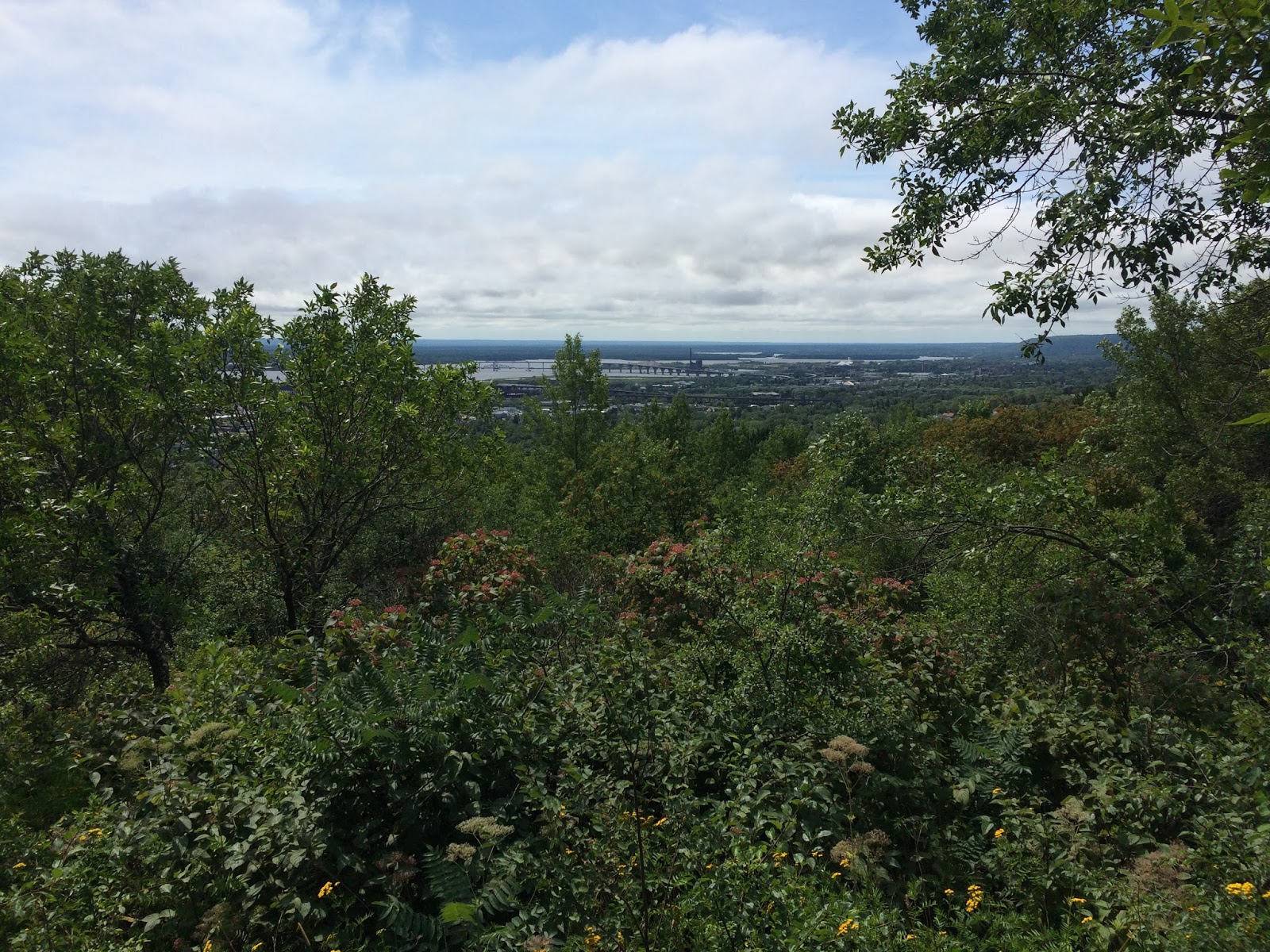
Once on level trail, we collected our ‘soil of the day’ and continued on
to the wide overlook of Lake Superior.
The view was impressive.

(Last view of the river before heading off to the woods)

(Location of today’s soil)
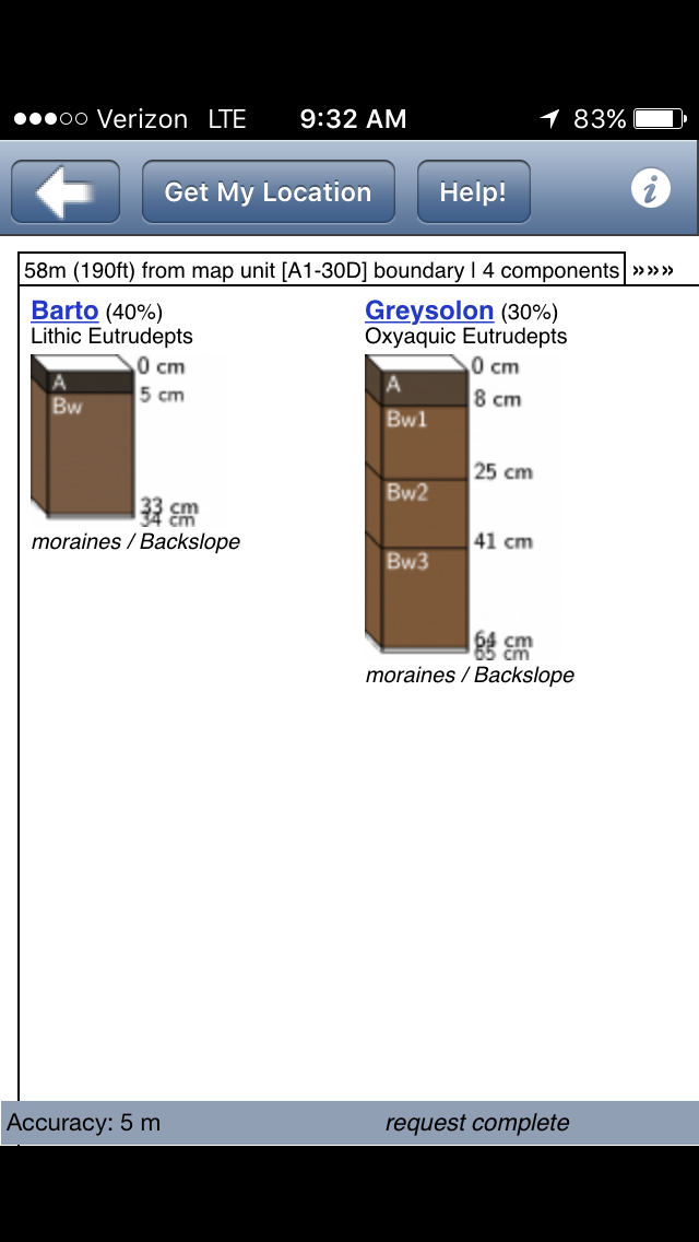
(Inceptisols with Lithic and Oxyaquic subgroups; moderately
developed soils that are shallow or periodically saturated)

(Wonderful trail placement!)
Wednesday, August 10, 2016
Back to Duluth
We squeezed in a sizable hike today from N. 24th
Ave to the Hartley Nature Center (about 13 miles). The weather forecast provided ample
motivation, and as I’m writing this Duluth is under a flash flood watch until
mid-morning tomorrow. Given the
expectation of soggy trails tomorrow and Friday, today was likely our last day
of vacation for hiking.
The route ran the gamut on elevation change, with >1100
feet at Enger Park, 600 feet along the Lakewalk, and >1300 at Hartley Nature
Center. Though challenging, conditions
were optimal with overcast skies, a cool north wind, and tacky (but not wet)
trails from a morning rain.
(Staying close to Skyline Parkway)

(Entering Enger Park)
It didn’t take long to reach the first major landmark 1.7
miles into the hike. Enger Tower did not
disappoint, with an excellent 360°
view of the area. We also took time to
view (but not ring) the Ohara Peace Bell, commemorating the friendship with
Duluth’s sister city, Ohara-Isumi, Japan.

(No problem with this tower standing strong in the wind)

(Soil type at the base of Enger Tower)

(Great view of the harbor from the top floor of the tower)
Gravity pushed us to the crossing of I-35, which was
quickly followed by Canal Park, the Lakewalk, and the Rose Garden. We were two hours into our hike (and feeling
good) when we started our journey up 14th Ave. en route to our final destination for the day.

(Bridge out = Additional mileage)

(The lift bridge)

(View from the Lakewalk)

(Alas, the roses – and the site of our second soil for the
day)

(No wonder they were growing so well!)
The remainder of the hike was a good workout for our legs
(due to the climbing) and even offered a few surprises from the recent storm
damage that kept us on our toes. All in
all, it was an excellent way to wrap up our hiking experiences during our Minnesota
vacation.

(Climbing along on Chester Creek Trail)

(Time to improvise)

(Yet more improvisation…)

(…and with good reason)

(Rewarded with a great view)
Tuesday, August 9, 2016
Hiking the Rivers: Cascade and Temperance
This was our day to explore areas north of Silver Bay, MN, a
section of Hwy 61 we didn’t visit during last year’s North Shore vacation. Along the way we hiked trails near two rivers
where the North Country Trail (aka Superior Hiking Trail) was conveniently
accessible from the highway. We stopped
at Cascade River on the way to Grand Marais and Temperance River on the way
back to Castle Danger. It was a hot day,
so we were glad we travelled north instead of continuing our hiking ventures in
Duluth where the afternoon temperatures reached the upper-80s.

(The Cascade River…)

(…and the location of the recorded soil)

(Wow, a shallow soil today! 5-8 cm of A horizon and then the Bw)

(Our turnaround point at Trout Creek)

(Moving on to Temperance River)

(Rock sculptures about a mile upriver… …creepy and disrespectful of the beautiful
surroundings)

(Approximate location of the soil along the Temperance)

(Makes one wonder if the soil type would have been the same
if we were standing in the middle of the river)

(On first blush, it seemed we were in Montana)
Monday, August 8, 2016
Among the Fallen Trees
Given the wet trail conditions following yesterday afternoon’s
hike, we decided to travel south to Duluth to hopefully find trails in better
condition. Starting from the Hartley
Nature Center promptly at 10:00 a.m., we headed out to Martin Road,
approximately three miles north.

(All business this morning: Left… Left… Left, Right, Left)
The first mile and a half were along paved and gravel roads
through quiet neighborhoods and two cemeteries (quieter still). Cemeteries typically elicit interest from
soil scientists since many are placed on undisturbed lands previously in native
vegetation. Given the forested area
along the North Shore, it’s doubtful there are cemeteries on undisturbed land,
though their land use history may not involve agriculture. In any case, we captured our soil for the day
between the Forest Hill and Park Hill cemeteries.

(Approximate location of today’s soil)

(Alfisols and Entisols yesterday; Inceptisols today)
Our hike became a bit challenging once we entered the singletrack
trail in Downer Park. The uneven rocky
terrain made us appreciate our footwear choices (or not), though the elevated
walkways were a welcome respite for all of us.

(Taking a quick break near Vermillion Ave.)

(Smooth sailing along this stretch, and definitely not
representative of what was to come)
We were amazed by the amount of work that had been done to
clear the trail following the massive windstorm on July 20th that
felled so many trees in the area.

(This would be impassable otherwise)
The fallen trees did provide a unique opportunity to view
the soil, however. Dark mollic colors
and granular structure dominated the surface 6-8” of soil, only to give way to
tan hues and numerous rock fragments below.

(Shallow roots and sandy soil… …not a good combination for strong winds)
Sunday, August 7, 2016
Beginning a week along the Superior Hiking Trail
Instead of continuing our journey from Riverdale, ND, we ventured east to Minnesota to hike along the Superior Hiking Trail (SHT) during
a long-overdue vacation. Fortunately for
us, the North Country Trail follows the SHT along it’s approximately 300 mile
distance. We intend to hike different
sections of the trail throughout the week.
Today we began our hiking at Gooseberry State Park; familiar
environs for us (we visited the park last year) and convenient, too (less than
two miles from our cabin). Our daughter,
Sarah, joined us for the hike along the 2.1 mile section north of the falls.

(Heading out mid-morning before the temperatures rise)

(Gooseberry River, middle falls section)

(Fifth falls bridge, and location of today’s recorded soil)

(Soil map units seem to make sense... Alfisol in a forest, Fluvent near a waterway)
It didn’t take long for us to reach the bridge, so we
continued south along the trail for another half mile. The extra hiking yielded a couple unexpected
finds. One was a huge ant hill (three
feet tall… …estimated from a safe
distance) and a large forest exclosure.

(Now that is some serious bioperturbation!)

(Vegetation and litter fall were denser in the exclosure
than adjacent forest)
Wild raspberries were abundant along the trail. I took full advantage of the opportunity to
try a ripe berry. Tart, but good.

(Plenty left for the bears)
Later in the day we traveled south to Castle Danger, MN to
climb up to Wolf Rock from Lake County Road 106. Though short, this was a significant hike
compared to our morning venture, but the view was worth it.

(A great view with a nice breeze to help cool off from the
climb)
We continued from Wolf Rock for about another mile to the
first primitive campsite. Trail conditions
were wet, so we decided to stop and return to the parking area.

(Our turnaround point for the afternoon)

(Lots of saturated soil and makeshift bridges)
As for the soil along this section, it was similar to we located this morning. Both were
along wooded areas of the trail, so the outcome wasn’t surprising.

(Who is Miskoaki?)
Subscribe to:
Posts (Atom)