Sunday, December 11, 2016

Audubon Refuge to McClusky Canal

This post is a bit late, as we completed our 100 mile goal last Saturday by hiking from Audubon Refuge to McClusky Canal, the longest hike of the year.  With a limited number of available days until the end of the year along with the uncertainty of suitable weather, we knew we needed to push ourselves to try to reach the century mile mark.  It’s good thing we did.  A ‘polar vortex’ has the entire state currently in the deep freeze, with no reprieve for at least another week.  Accordingly, I’m not sure if we’ll return to hike this year.  Our ‘comfort limit’ is air temperatures in the teens (°F) with limited wind.  Those weather days may be rare throughout December.

We started our drive to the trail with some trepidation.  Our first snow of the winter was a whopper, with nearly two feet of snow extending from Bismarck to Washburn.  We were certain we’d be trudging through deep snow for at least the first 2.3 miles into the refuge.  Fortunately, that wasn’t the case.  The gravel roads were mostly open with snowpack only along the edges.  The snow on the road allowed us to vary our walking surface, which was welcome considering the mileage.  Snow is softer than gravel!.

We did an out-and-back from the entrance of the refuge to the terminus of our hike the previous week.  It was a good way to warm-up our legs and lungs while watching and listening to the geese and ducks along the lake’s edge.

(First ice of the year on Lake Audubon)

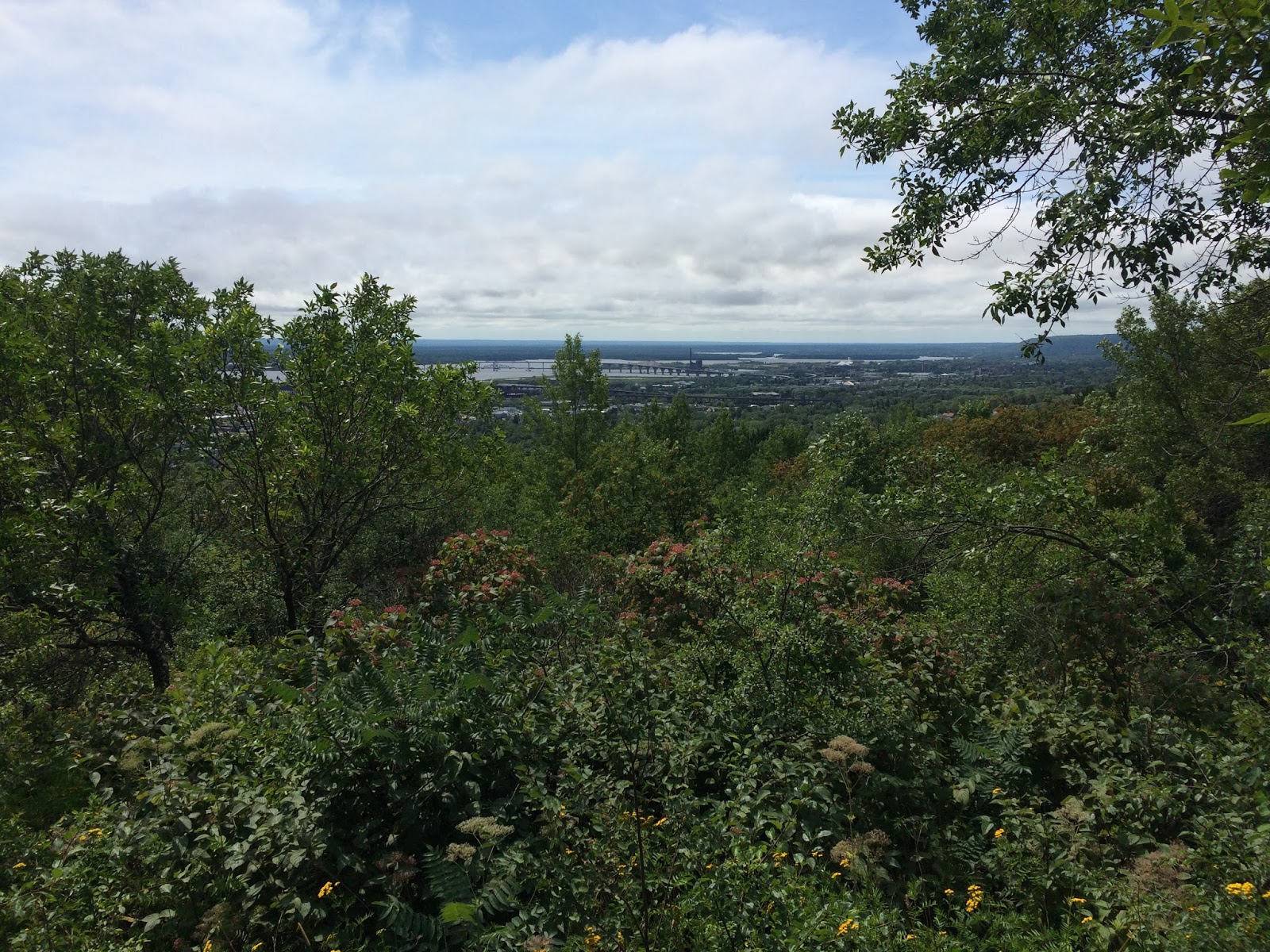
After the out-and-back we drove to the McClusky Canal and leapfrogged our way back to the refuge entrance.  Doing so allowed us to warm up in the truck every two miles.

(Today’s terminus…   …The beginning of the McClusky Canal)

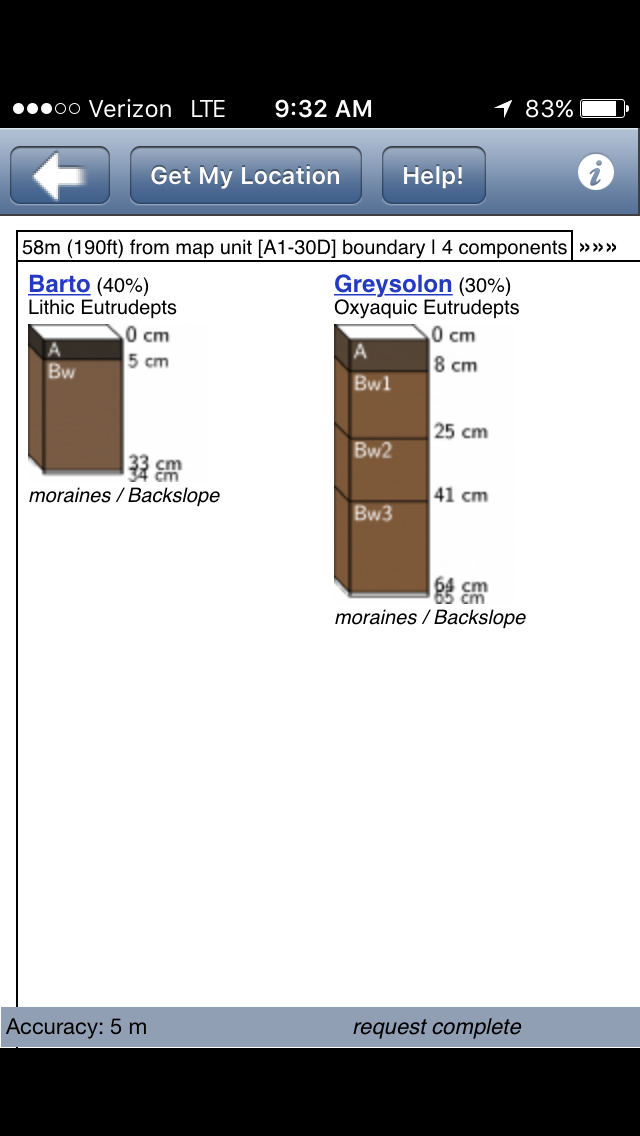
Today’s soil was another Haplustoll.  Given that we’ve been hiking along the same landscape since Riverdale (rolling uplands), the lack of variation isn’t surprising.  In fact, we’ll likely be hiking through Haplustoll’s for a while longer until we’re further into the Missouri Coteau.

(Today’s soil)

(A rare irrigation pivot along the trail, and the site of today’s soil)

By mid-afternoon the sun was its most intense, resulting in us removing a few layers before heading out to hike another section of trail.  Most of the trail was a straight shot along a gravel road, so we kept a decent pace and made good time.

(Open road on the way back to the refuge entrance)

It was a good feeling to complete our goal for 2016, as we weren’t completely certain we’d be able to reach 100 miles given our crazy schedules throughout the year.  Winter hiking may be something we’ll do once reasonable temperatures return, as our schedules are somewhat open January through March.  Perhaps Santa Claus will bring snowshoes for Christmas so we can continue our mileage along the North Country Trail. ☺

(Arrived!)

Sunday, November 27, 2016

Audubon National Wildlife Refuge

We continued from Coleharbor through most of the Audubon National Wildlife Refuge on a rare day weatherwise.  Temperatures peaked in the low-50s under mostly sunny skies.  There was also an absence of wind, which is about as rare in North Dakota as a late November day in the 50s.

Given the benefit of good weather and the forecast of significant snow Sunday through Wednesday, we pushed our mileage for the day to just under 13 miles.  Of course, we had to backtrack along the way to reposition our vehicle, but doing so gave us two perspectives of the trail.

(Clear skies on the road to Coleharbor)

(Water as smooth as glass)

Audubon National Wildlife Refuge is a special place, positioned along the edge of Lake Audubon, approximately 2.5 miles north of Coleharbor.  There is an abundance of islands and wetlands within and along the lake that create an ideal habitat for migrating birds.  Though most had left for the winter, there remained a large contingent of Canada and Snow geese on the lake.  We also spotted a pair of bald eagles early in the day and three otters in a wetland near the trail.

(Interpretive signs and a spotting scope along the trail)

(Dike protecting wetland habitat from large waves)

(Otters perched on thin ice)

We tried to capture a soil with wetland attributes, but the Soil Web app repeatedly came up with variations of a Williams loam.  Today’s soil was a combination of Zahl and Williams, both formed from calcareous glacial till.

(Today’s soil)

Perhaps the most memorable part of the hike was watching and listening to hundreds of geese take flight from the middle of the lake.  Even though they were easily a mile from shore, the collective ‘whoosh’ of their wings created a low rumble not unlike a large jet engine.

(Geese taking flight)

Sunday, November 20, 2016

Sharing the Trail with Deer Hunters

We snuck in a quick 10 miles today beginning in Coleharbor and hiking west and south to the terminus of our previous hike in October.  Temperatures were brisk, with wind chills well below 32°F.

With much of the trail adjacent to Wolf Creek Public Use Area, we shared the trail with numerous hunters, as today was the final day deer gun season.  I’m sure many were perplexed by our decision to hike on a busy hunting day.

(Wolf Creek area was to the north of the trail)

(View of Lake Sakakawea)

We logged a very similar soil to what we found in October.  The Williams-Bowbells soil is characterized as Typic and Pachic Hapustolls.  A very good agricultural soil!

(Today’s soil)

(Turnaround point for today)

Many migratory birds were in flight today; a reflection of the changing seasons.  We weren’t sure why they were moving north, however.

(Northbound geese)

(Fortunately, the sun popped out on the return leg to Coleharbor)


With the completion of this section of the trail, we are now east of Highway 83.  Our next hike will take us into Audubon National Wildlife Refuge.  Something to look forward to!

Sunday, October 16, 2016

Onward Past Riverdale

With winter weather fast approach we took advantage of ideal temperatures this morning to log in some miles on the trail.  Beginning where we left off in July (Corp of Engineers Administrative Building), we headed east and then north of Riverdale along both paved and dirt roads.

(Heading east out of town…)

(…and then north along a tree line)

Light rain was followed by a moderate southeast wind, providing a nice push north.  On the way we enjoyed a vista of the lake, along with fields of recently harvested peas and soon-to-be harvested corn.

(Lake Sakakawea, looking northwest)

(Dry pea residue)

(An aberration on today’s journey…   …a carpet of cover crops in wheat residue)


(Mostly on gravel roads today)

The soil for this leg was a mix of Temvik and Wilton silt loams (Typic and Pachic Haplustolls).  Both are very good soils for agricultural production, and are found most frequently in Emmons County.


(Location of today’s soil)


(Today’s soil)

After five miles we decided to retrace our steps, stopping periodically for refreshments and bathroom breaks.  The highlight of our return journey was a close-up visit with some horses.  One was particularly friendly.


(They rushed to the fence as we passed by)

(This one seemed ready to join us for the rest of the hike!)

Monday, August 29, 2016

Traveling Well-Trodden Paths

A recent article in Eos provided a nice - though somewhat technical - geological review of the area including the Superior Hiking Trail.  I didn't realize we were passing over terrain exceeding one billion years old.  Enjoy!

Friday, August 12, 2016

Split Rock River Loop

Trail conditions dried enough for us to sneak in one more hike the morning before our departure, so we headed north to Split Rock Lighthouse State Park, a mere four miles from our cabin.  A light dew made the trail a bit slippery in places, but we took it slow and used our hiking sticks for occasional support.  Starting on the west side, we enjoyed close-up views of the fast running river, still swollen with water from recent rains.

(The river moving along at a good pace)

(The split rock)

(We were able to get close to the river, so here’s a video)

(Over the bridge and back the other side)

After crossing the Split Rock River bridge, the trail climbed north and away from the river.  Once on level trail, we collected our ‘soil of the day’ and continued on to the wide overlook of Lake Superior.  The view was impressive.

(Last view of the river before heading off to the woods)

(Location of today’s soil)

(Inceptisols with Lithic and Oxyaquic subgroups; moderately developed soils that are shallow or periodically saturated)

(Wonderful trail placement!)

Wednesday, August 10, 2016

Back to Duluth

We squeezed in a sizable hike today from N. 24th Ave to the Hartley Nature Center (about 13 miles).  The weather forecast provided ample motivation, and as I’m writing this Duluth is under a flash flood watch until mid-morning tomorrow.  Given the expectation of soggy trails tomorrow and Friday, today was likely our last day of vacation for hiking.

The route ran the gamut on elevation change, with >1100 feet at Enger Park, 600 feet along the Lakewalk, and >1300 at Hartley Nature Center.  Though challenging, conditions were optimal with overcast skies, a cool north wind, and tacky (but not wet) trails from a morning rain.

(Staying close to Skyline Parkway)

(Entering Enger Park)

It didn’t take long to reach the first major landmark 1.7 miles into the hike.  Enger Tower did not disappoint, with an excellent 360° view of the area.  We also took time to view (but not ring) the Ohara Peace Bell, commemorating the friendship with Duluth’s sister city, Ohara-Isumi, Japan.

(No problem with this tower standing strong in the wind)

(Soil type at the base of Enger Tower)

(Great view of the harbor from the top floor of the tower)

Gravity pushed us to the crossing of I-35, which was quickly followed by Canal Park, the Lakewalk, and the Rose Garden.  We were two hours into our hike (and feeling good) when we started our journey up 14th Ave. en route to our final destination for the day.

(Bridge out = Additional mileage)

(The lift bridge)

(View from the Lakewalk)

(Alas, the roses – and the site of our second soil for the day)

(No wonder they were growing so well!)

The remainder of the hike was a good workout for our legs (due to the climbing) and even offered a few surprises from the recent storm damage that kept us on our toes.  All in all, it was an excellent way to wrap up our hiking experiences during our Minnesota vacation.

(Climbing along on Chester Creek Trail)

(Time to improvise)

(Yet more improvisation…)

(…and with good reason)

(Rewarded with a great view)